
Landscape Photography

Dewey Lake by Dowagiac Aerial Photo from SE
Dewey Lake is located near Dowagiac in Cass County in Michigan's lower peninsula. This aerial photo was taken from southeast of the lake on a summer day in 2024.
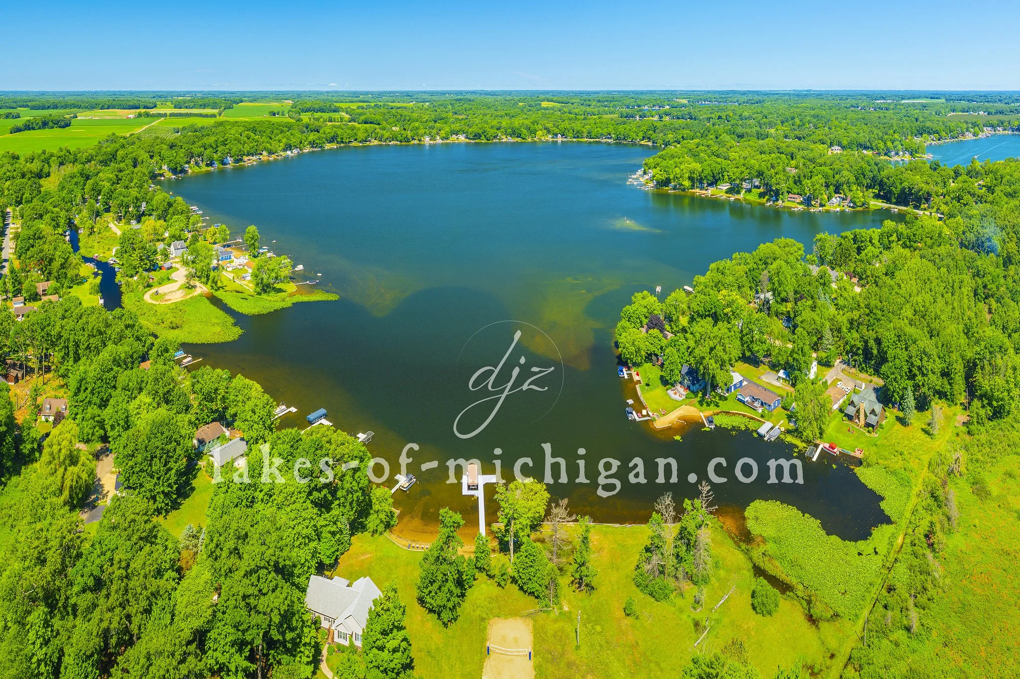
Dewey Lake is located near Dowagiac in Cass County in Michigan's lower peninsula. This aerial photo was taken from southeast of the lake on a summer day.

Muskegon South Pierhead and Breakwater Lights with Full Moon - May 23rd, 2024
This photo of the Muskegon Lights was taken on May 23rd, 2024 as the full moon positioned itself behind the South Pierhead Lighthouse before setting into the waters of Lake Michigan.

This photo of the Muskegon Lights was taken on May 23rd, 2024 as the full moon positioned itself behind the South Pierhead Lighthouse before setting into the waters of Lake Michigan.

Muskegon Beach & Piers Aerial Photo from South
This aerial photo at the Pere Marquette Park in Muskegon features the beach, piers, lighthouses, and The Deck bar & restaurant. (June 2022)

This 2022 aerial photo at the Pere Marquette Park in Muskegon features the beach, piers, lighthouses, and The Deck bar & restaurant.

Grand Traverse Bay West Arm Marinas from NW - Summer 2021
This aerial photo along Grand Traverse Bay was taken on a summer morning in July 2021 from north of the marinas facing southeast towards Traverse City.

This aerial photo along Grand Traverse Bay was taken on a summer morning in July 2021 from north of the marinas facing southeast towards Traverse City.

Kalamazoo Lake near Saugatuck and Douglas Aerial Photo from SE
Kalamazoo Lake is located along the Kalamazoo River between Saugatuck and Douglas in Allegan County in Michigan's lower peninsula. This aerial photo was taken from southeast of the lake on a sunny summer morning.

Kalamazoo Lake is located along the Kalamazoo River between Saugatuck and Douglas in Allegan County in Michigan's lower peninsula. This aerial photo was taken from southeast of the lake on a sunny summer morning.

Northport Bay on the Leelanau Peninsula Aerial Photo from West - 2022
Northport Bay is located near the northern tip of the Leelanau Peninsula in Leelanau County near Northport, which is about a 25 mile drive north from Traverse City in Michigan's lower peninsula. This 2022 aerial photo of the bay features E Nagonaba St in the lower left, pointing towards the marina and the turquoise waters of the bay.

Northport Bay is located near the northern tip of the Leelanau Peninsula in Leelanau County near Northport, which is about a 25 mile drive north from Traverse City in Michigan's lower peninsula. This 2022 aerial photo of the bay features E Nagonaba St in the lower left, pointing towards the marina and the turquoise waters of the bay.

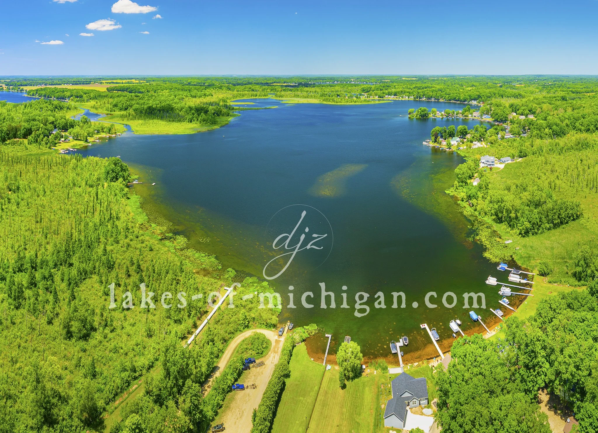
Cable Lake near Dowagiac Aerial Photo from East
Cable Lake is located near Dowagiac in Cass County in Michigan's lower peninsula. This aerial photo was taken from east of the lake on a summer day.

Cable Lake is located near Dowagiac in Cass County in Michigan's lower peninsula. This aerial photo was taken from east of the lake on a summer day.

Lake Templene near Sturgis Aerial Photo from West
Lake Templene is located southeast of Three Rivers and north of Sturgis in St. Joseph County in Michigan's lower peninsula. This aerial photo was taken from west of the lake on a summer day.

Lake Templene is located southeast of Three Rivers and north of Sturgis in St. Joseph County in Michigan's lower peninsula. This aerial photo was taken from west of the lake on a summer day.

Donnell Lake near Vandalia Aerial Photo from East
Donnell Lake is located near Vandalia in Cass County in Michigan's lower peninsula. This aerial photo was taken from east of the lake on a summer day.

Donnell Lake is located near Vandalia in Cass County in Michigan's lower peninsula. This aerial photo was taken from east of the lake on a summer day.

Fish Lake by Marcellus Aerial Photo from South
Fish Lake is located near Marcellus in Cass County in Michigan's lower peninsula. This aerial photo was taken from south of the lake on a summer day.
Fish Lake is located near Marcellus in Cass County in Michigan's lower peninsula. This aerial photo was taken from south of the lake on a summer day.

Portage Lake near Three Rivers Aerial Photo from SW
Portage Lake is located near Three Rivers in St. Joseph County in Michigan's lower peninsula. This aerial photo was taken from southwest of the lake on a summer day.

Portage Lake is located near Three Rivers in St. Joseph County in Michigan's lower peninsula. This aerial photo was taken from southwest of the lake on a summer day.

Pleasant Lake near Three Rivers Aerial Photo from SW
Pleasant Lake is located near Three Rivers in St. Joseph County in Michigan's lower peninsula. This aerial photo was taken from southwest of the lake on a summer day.

Pleasant Lake is located near Three Rivers in St. Joseph County in Michigan's lower peninsula. This aerial photo was taken from southwest of the lake on a summer day.

Shavehead Lake near Cassopolis Aerial Photo from South
Shavehead Lake is located near Cassopolis and Vandalia in Cass County in Michigan's lower peninsula. This aerial photo was taken from south of the lake on a summer day.

Shavehead Lake is located near Cassopolis and Vandalia in Cass County in Michigan's lower peninsula. This aerial photo was taken from south of the lake on a summer day.

Long Lake near Three Rivers Aerial Photo from SW
Long Lake is located near Three Rivers bordering St. Joseph and Cass Counties in Michigan's lower peninsula. This aerial photo was taken from southwest of the lake on a summer day.

Long Lake is located near Three Rivers bordering St. Joseph and Cass Counties in Michigan's lower peninsula. This aerial photo was taken from southwest of the lake on a summer day.

Juno Lake near Edwardsburg Aerial Photo from East
Juno Lake is located near Edwardsburg in Cass County in Michigan's lower peninsula. This aerial photo was taken on a summer day from east of the lake. Christiana and Painter Lake, shown in the background, are connected to Juno Lake.

Juno Lake is located near Edwardsburg in Cass County in Michigan's lower peninsula. This aerial photo was taken on a summer day from east of the lake. Christiana and Painter Lake, shown in the background, are connected to Juno Lake.

Eagle Lake near Edwardsburg Aerial Photo from East
Eagle Lake is located near Edwardsburg in Cass County, in Michigan's lower peninsula. This aerial photo was taken from east of the lake on a quiet weekday afternoon in the summer.

Eagle Lake is located near Edwardsburg in Cass County, in Michigan's lower peninsula. This aerial photo was taken from east of the lake on a quiet weekday afternoon in the summer.

Clear Lake near Three Rivers Aerial Photo from South
Clear Lake is located near Three Rivers in is St. Joseph County in Michigan's lower peninsula. This aerial photo was taken from south of the lake on a sunny summer weekday.
Clear Lake is located near Three Rivers in is St. Joseph County in Michigan's lower peninsula. This aerial photo was taken from south of the lake on a sunny summer weekday.

Corey Lake near Three Rivers Aerial Photo from East
Corey Lake is located near Three Rivers in St. Joseph County in Michigan's lower peninsula. This aerial photo was taken on a summer day from east of the lake.

Corey Lake is located near Three Rivers in St. Joseph County in Michigan's lower peninsula. This aerial photo was taken on a summer day from east of the lake.

Barron Lake near Niles Aerial Photo from NE
Barron Lake is located near Niles in Cass County in Michigan's lower peninsula. This aerial photo was taken from northeast of the lake on a quiet weekday in the summer.

Barron Lake is located near Niles in Cass County in Michigan's lower peninsula. This aerial photo was taken from northeast of the lake on a quiet weekday in the summer.

Pentwater Piers, Beach, and Lighthouse Aerial Photo from West
This aerial photo of the Pentwater Piers, Beach, and Lighthouse was taken from west of the lighthouse on a sunny summer afternoon. Pentwater Lake is in the background with Mears State Park along the shoreline.

This aerial photo of the Pentwater Piers, Beach, and Lighthouse was taken from west of the lighthouse on a sunny summer afternoon. Pentwater Lake is in the background with Mears State Park along the shoreline.