
Landscape Photography

Kalamazoo Lake near Saugatuck and Douglas Aerial Photo from SE
Kalamazoo Lake is located along the Kalamazoo River between Saugatuck and Douglas in Allegan County in Michigan's lower peninsula. This aerial photo was taken from southeast of the lake on a sunny summer morning.

Kalamazoo Lake is located along the Kalamazoo River between Saugatuck and Douglas in Allegan County in Michigan's lower peninsula. This aerial photo was taken from southeast of the lake on a sunny summer morning.

Aerial Photo of Mackinaw City, Michigan
This aerial photo of Mackinaw Cityfeatures Conkling Heritage Park and the Straits State Harbor marina in the foreground with the Mackinac Bridge and Mackinac Island in the distance.

Mackinaw City is located at the northern tip of Michigan's lower peninsula, bordering Cheboygan and Emmet counties. This aerial photo features Conkling Heritage Park and the Straits State Harbor marina in the foreground with the Mackinac Bridge and Mackinac Island in the distance.
Prints are available to purchase by clicking the on the image above or by visiting lakes-of-michigan.com.

Mackinac Bridge with Full Moon on June 14th, 2022
The full moon creates reflections on the water as it begins to set over the Mackinac Bridge. This photo was taken from the western shores of Mackinac Island on June 14th, 2022 as the pre-dawn sun began saturating the sky behind me with shades of orange and red.

The full moon creates reflections on the water as it begins to set over the Mackinac Bridge. This photo was taken from the western shores of Mackinac Island on June 14th, 2022 as the pre-dawn sun began saturating the sky behind me with shades of orange and red.
Prints are available to purchase by clicking the on the image above or by visiting lakes-of-michigan.com.

Old Mackinac Point Lighthouse with Mackinac Bridge Morning Aerial Photo
The Old Mackinac Point Lighthouse is located in Alexander Henry Park in Mackinaw City at the northern tip of Michigan's lower peninsula. This photo, which also features the Mackinac Bridge, was taken on a summer morning.

The Old Mackinac Point Lighthouse is located in Alexander Henry Park in Mackinaw City at the northern tip of Michigan's lower peninsula. This photo, which also features the Mackinac Bridge, was taken on a summer morning.
Prints are available to purchase by clicking the image above or by visiting lakes-of-michigan.com.

Maple Lake near Paw Paw Aerial Photo from North with Fall Colors
Maple Lake is located in the city of Paw Paw about 15 miles west of Kalamazoo in Van Buren County in Michigan's lower peninsula. This aerial photo was taken on a fall day from north of the lake during peak fall foliage colors.

Maple Lake is located in the city of Paw Paw about 15 miles west of Kalamazoo in Van Buren County in Michigan's lower peninsula. This aerial photo was taken on a fall day from north of the lake during peak fall foliage colors.
Prints are available to purchase by clicking the image above or by visiting lakes-of-michigan.com.
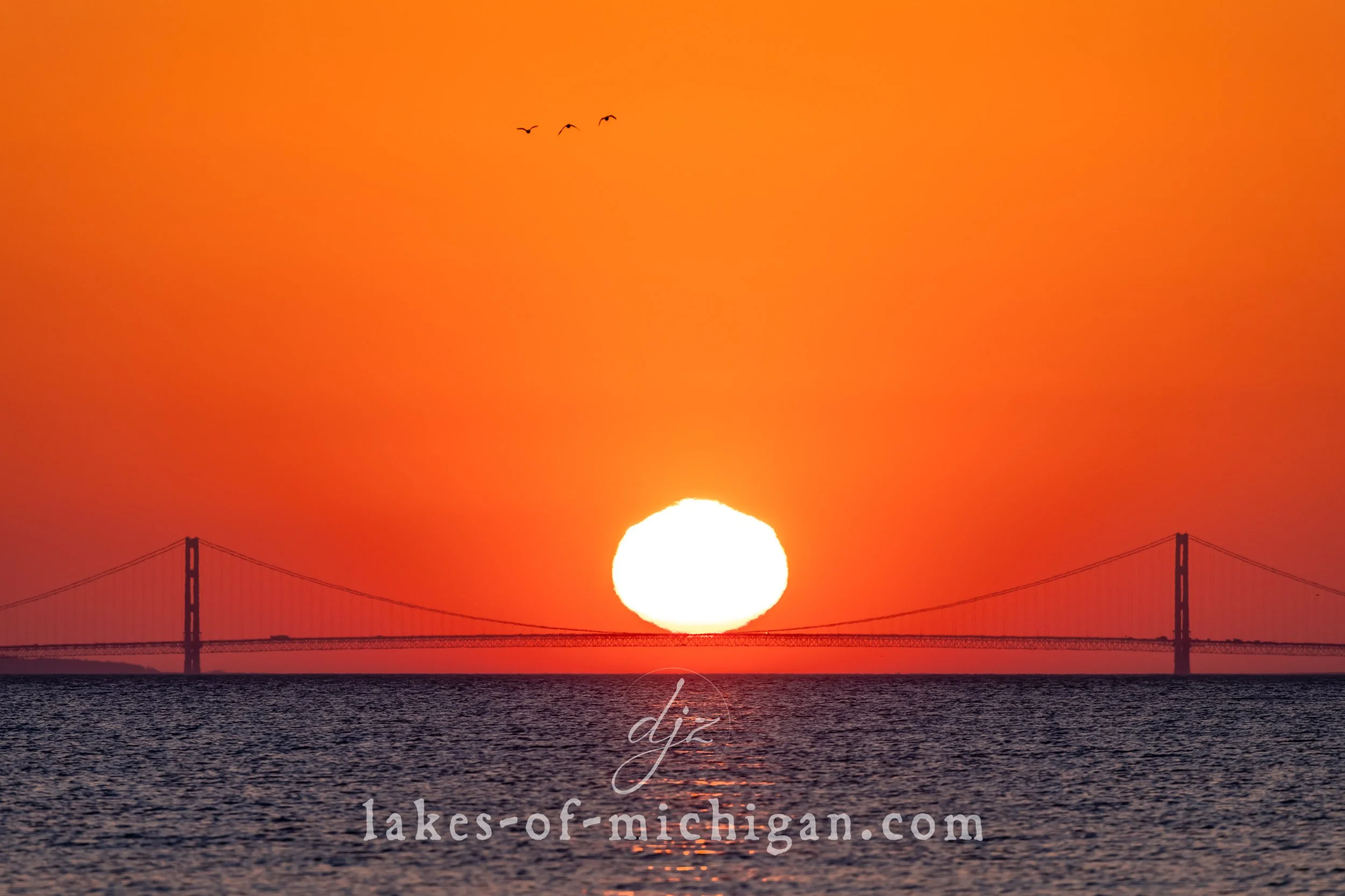
Mackinac Bridge at Sunrise 2021
This photo of the Mackinac Bridge at sunrise was taken from over 12 miles away when the sun was perfectly aligned to appear as if it was weighing down the bridge's cables while resting on the midspan of the bridge.

This photo of the Mackinac Bridge at sunrise was taken from over 12 miles away when the sun was perfectly aligned to appear as if it was weighing down the bridge's cables while resting on the midspan of the bridge.
Prints are available to purchase by clicking the image above or by visiting lakes-of-michigan.com.

Mackinac Bridge Annular Solar Eclipse Sunrise
This photo was taken on June 10th, 2021 at around 6am from McGulpin Rock facing northeast towards the south tower of the Mackinac Bridge as the sun rose during a partial solar eclipse.

This photo was taken on June 10th, 2021 at around 6am from McGulpin Rock facing northeast towards the south tower of the Mackinac Bridge as the sun rose during a partial solar eclipse.
Prints are available to purchase by clicking the image above or by visiting lakes-of-michigan.com.

Little Glen Lake near Glen Arbor Aerial Photo from SE
Situated near Glen Arbor & Sleeping Bear Dunes northeast of Empire in Leelanau County, Glen Lake is comprised of two segments known as Big Glen Lake and Little Glen Lake. If you take M22 from Glen Arbor to Empire, you can enjoy beautiful views of the lake from the bridge that passes between the two sections. This aerial photo was taken from southeast of Little Glen Lake on a summer afternoon, and also shows a bit of the big part of Glen Lake where M22 separates the two sections.

Situated near Glen Arbor & Sleeping Bear Dunes northeast of Empire in Leelanau County, Glen Lake is comprised of two segments known as Big Glen Lake and Little Glen Lake. If you take M22 from Glen Arbor to Empire, you can enjoy beautiful views of the lake from the bridge that passes between the two sections. This aerial photo was taken from southeast of Little Glen Lake on a summer afternoon, and also shows a bit of the big part of Glen Lake where M22 separates the two sections.
Prints are available to purchase by clicking the image above or by visiting lakes-of-michigan.com.

Little Glen Lake near Glen Arbor Aerial Photo from SE 2020
Situated near Glen Arbor & Sleeping Bear Dunes NE of Empire in Leelanau County, Glen Lake is comprised of two segments known as Big Glen Lake and Little Glen Lake. This aerial photo was taken from SE of Little Glen Lake on a summer afternoon.

Situated near Glen Arbor & Sleeping Bear Dunes NE of Empire in Leelanau County, Glen Lake is comprised of two segments known as Big Glen Lake and Little Glen Lake. This aerial photo was taken from SE of Little Glen Lake on a summer afternoon.
Prints are available to purchase by clicking the image above or by visiting lakes-of-michigan.com.

Fort Michilimackinac and Mackinac Bridge Aerial Photo from SW
This aerial photo of Fort Michilimackinac and the Mackinac Bridge was taken on a summer afternoon from southwest of the fort, featuring Mackinac Island and the Round Island Lighthouse in the distance.

This aerial photo of Fort Michilimackinac and the Mackinac Bridge was taken on a summer afternoon from southwest of the fort, featuring Mackinac Island and the Round Island Lighthouse in the distance.
Prints are available to purchase by clicking the image above or by visiting lakes-of-michigan.com.

Croton Dam & Pond Aerial Photo from South
The Croton Dam is located about 7 miles ENE of Newaygo in Newaygo County in Michigan's lower peninsula. This aerial photo was taken in the summer from south of the dam facing north.

The Croton Dam is located about 7 miles ENE of Newaygo in Newaygo County in Michigan's lower peninsula. This aerial photo was taken in the summer from south of the dam facing north.
Prints are available to purchase by clicking the image above or by visiting lakes-of-michigan.com.

Charlevoix South Pier Light Station Aerial Photo from SW
This is an aerial photo of the beach, piers and lighthouse in Charlevoix on the northwest shores of Charlevoix County in Michigan's lower peninsula. In the background of this photo we can see Round Lake just beyond the bridge with Lake Charlevoix in the distance. This photo was taken on a hot, hazy summer afternoon.

This is an aerial photo of the beach, piers and lighthouse in Charlevoix on the northwest shores of Charlevoix County in Michigan's lower peninsula.
Prints are available to purchase by clicking the image above or by visiting lakes-of-michigan.com.

Big & Little Glen Lake with M22 Aerial Photo from SW
Situated near Glen Arbor & Sleeping Bear Dunes northeast of Empire in Leelanau County, Glen Lake is comprised of two segments known as Big Glen Lake and Little Glen Lake. If you take M22 from Glen Arbor to Empire, you can enjoy beautiful views of the lake from the bridge that passes between the two sections. This aerial photo was taken from SW of the Glen Lake Narrows and M22 bridge on a summer afternoon.

Situated near Glen Arbor & Sleeping Bear Dunes northeast of Empire in Leelanau County, Glen Lake is comprised of two segments known as Big Glen Lake and Little Glen Lake. If you take M22 from Glen Arbor to Empire, you can enjoy beautiful views of the lake from the bridge that passes between the two sections. This aerial photo was taken from SW of the Glen Lake Narrows and M22 bridge on a summer afternoon.
Prints are available to purchase by clicking the image above or by visiting lakes-of-michigan.com.
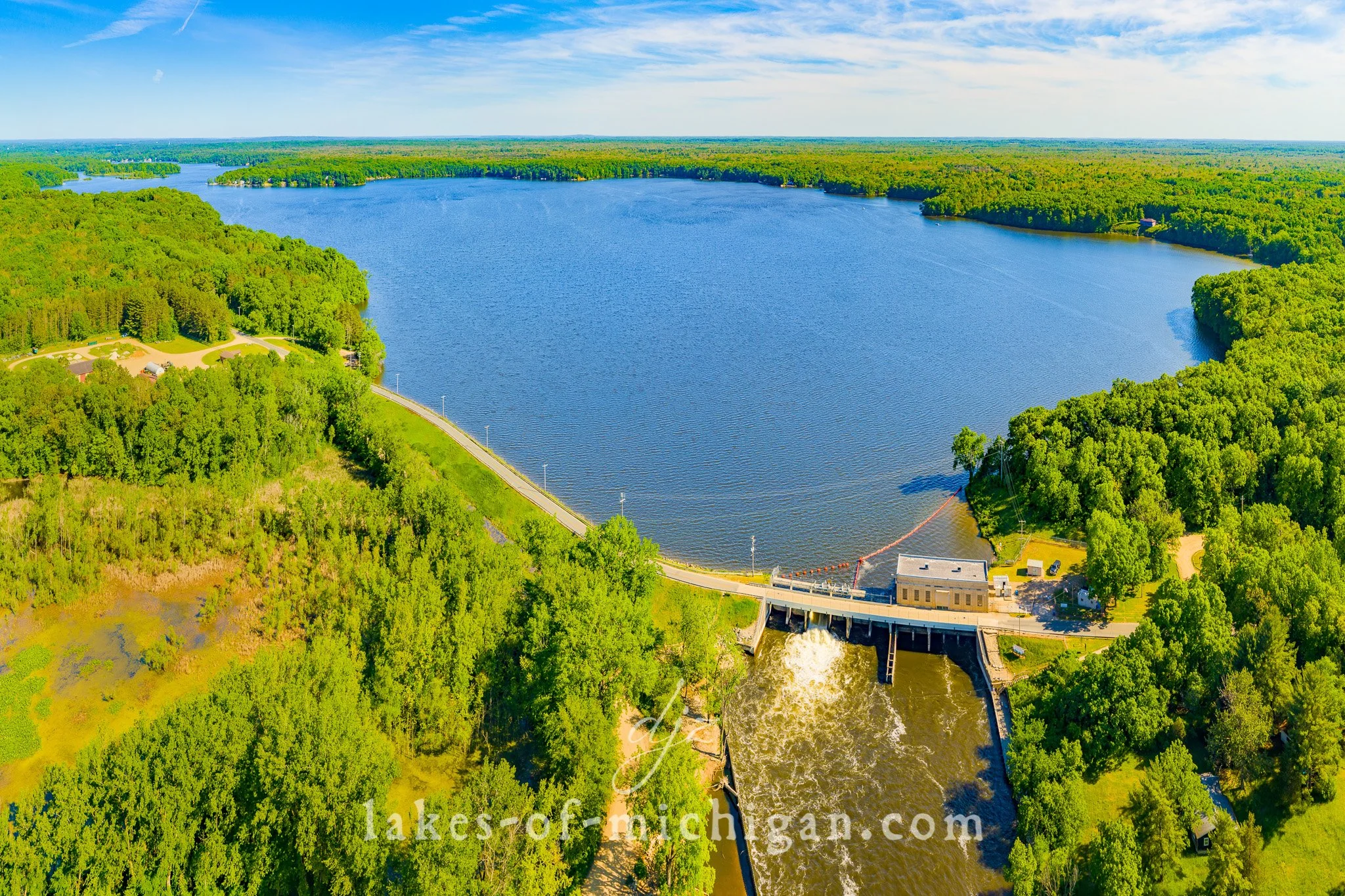
Allegan Dam with lake Allegan Aerial Photo from NW - 3x2 Ratio
Lake Allegan and the Allegan Dam are located just northwest of Allegan in Allegan County in Michigan's lower peninsula. This aerial photo was taken on a summer afternoon from NW of the lake.

Lake Allegan and the Allegan Dam are located just northwest of Allegan in Allegan County in Michigan's lower peninsula. This aerial photo was taken on a summer afternoon from NW of the lake.
Prints are available to purchase by clicking the image above or by visiting lakes-of-michigan.com.