
Landscape Photography
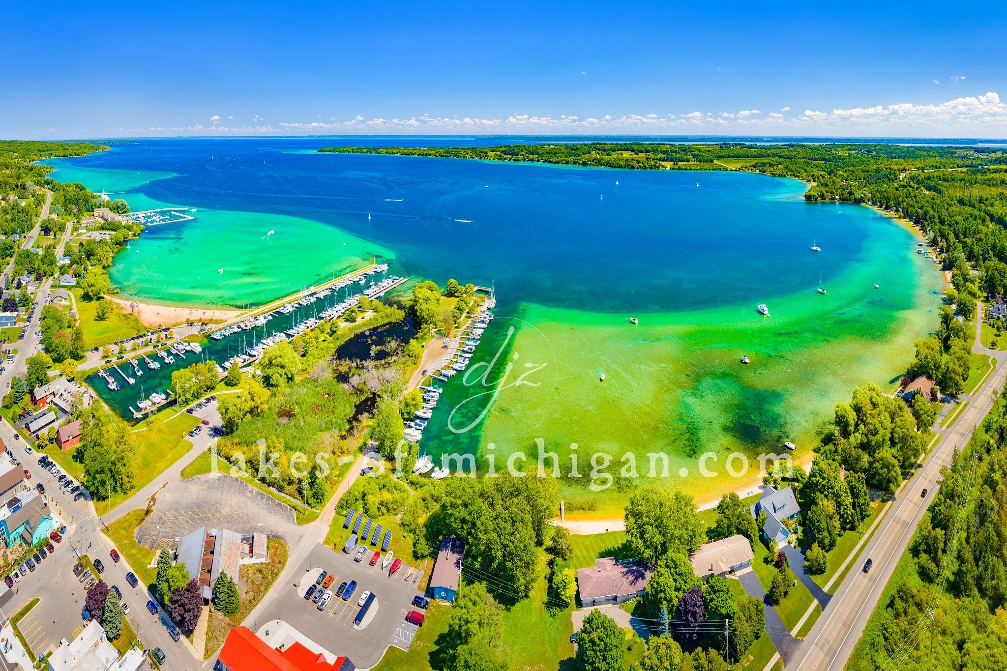
Suttons Bay on the Leelanau Peninsula Aerial Photo from W
Suttons Bay is located on the east side of the Leelanau Peninsula on Grand Traverse Bay, about 16 miles north of Traverse City in Michigan's lower peninsula. This aerial photo was taken from west of the bay on a summer day.

Suttons Bay is located on the east side of the Leelanau Peninsula on Grand Traverse Bay, about 16 miles north of Traverse City in Michigan's lower peninsula. This aerial photo was taken from west of the bay on a summer day.
Prints are available to purchase by clicking the image above or by visiting lakes-of-michigan.com.

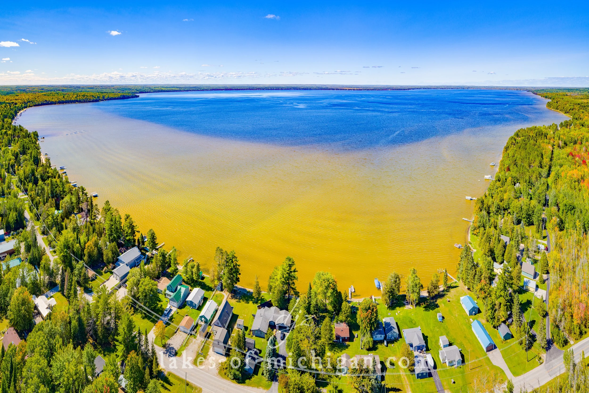
Cass Lake near Pontiac Aerial Photo from West in the Fall
Cass Lake is located southwest of Pontiac in Michigan's lower peninsula, near West Bloomfield Township and Orchard Lake Village in Oakland County. This aerial photo was taken west of the lake in the fall during peak foliage color.

Cass Lake is located southwest of Pontiac in Michigan's lower peninsula, near West Bloomfield Township and Orchard Lake Village in Oakland County. This aerial photo was taken west of the lake in the fall during peak foliage color.
Prints are available to purchase by clicking the image above or by visiting lakes-of-michigan.com.

Canadian Lakes near Big Rapids Aerial Photo from NE
Canadian Lakes is located about 10 miles southeast of Big Rapids, near the center of Michigan's lower peninsula in Mecosta County. This aerial photo was taken from northeast of the lake in the early fall.

Canadian Lakes is located about 10 miles southeast of Big Rapids, near the center of Michigan's lower peninsula in Mecosta County. This aerial photo was taken from northeast of the lake in the early fall.
Prints are available to purchase by clicking the image above or by visiting lakes-of-michigan.com.

Burt Lake near Indian River Aerial Photo from SE
Burt Lake is located near Indian River, south of Cheboygan and east of Petoskey in Cheboygan County in Michigan's lower peninsula. This aerial photo was taken southeast of the lake in mid-September.

Burt Lake is located near Indian River, south of Cheboygan and east of Petoskey in Cheboygan County in Michigan's lower peninsula. This aerial photo was taken southeast of the lake in mid-September.
Prints are available to purchase by clicking the image above or by visiting lakes-of-michigan.com.

Brower Lake near Rockford Aerial Photo from South
Brower Lake is located about 4 miles east of Rockford and 14 miles NE of Grand Rapids in Kent County in Michigan's lower peninsula. This aerial photo was taken from south of the lake on a summer morning.

Brower Lake is located about 4 miles east of Rockford and 14 miles NE of Grand Rapids in Kent County in Michigan's lower peninsula. This aerial photo was taken from south of the lake on a summer morning.
Prints are available to purchase by clicking the image above or by visiting lakes-of-michigan.com.

Bowers Harbor near Traverse City Aerial Photo from NE
Bowers Harbor is located on Old Mission Peninsula on the West Arm of Grand Traverse Bay, about 10 miles North of Traverse City in Grand Traverse County. This aerial photo was taken northeast of the harbor on a summer day.

Bowers Harbor is located on Old Mission Peninsula on the West Arm of Grand Traverse Bay, about 10 miles North of Traverse City in Grand Traverse County. This aerial photo was taken northeast of the harbor on a summer day.
Prints are available to purchase by clicking the image above or by visiting lakes-of-michigan.com.

Bostwick Lake near Rockford Aerial Photo from North
Located near Cannonsburg and Rockford, Bostwick Lake is about 13 Miles Northeast of Grand Rapids in Kent County in Michigan's lower peninsula. This aerial photo was taken from north of the lake on a summer day.

Located near Cannonsburg and Rockford, Bostwick Lake is about 13 Miles Northeast of Grand Rapids in Kent County in Michigan's lower peninsula. This aerial photo was taken from north of the lake on a summer day.
Prints are available to purchase by clicking the image above or by visiting lakes-of-michigan.com.

Blue Lake & North Blue Lake Aerial Photo from North
Blue Lake & North Blue Lake are located in Blue Lake Township NE of Kalkaska, NW of Grayling, and SW of Gaylord in Kalkaska County in Michigan's lower peninsula. This aerial photo was taken from north of the lakes on a September morning.

Blue Lake & North Blue Lake are located in Blue Lake Township NE of Kalkaska, NW of Grayling, and SW of Gaylord in Kalkaska County in Michigan's lower peninsula. This aerial photo was taken from north of the lakes on a September morning.
Prints are available to purchase by clicking the image above or by visiting lakes-of-michigan.com.

Blue Lake & North Blue Lake Aerial Photo from S
Blue Lake & North Blue Lake are located in Blue Lake Township northeast of Kalkaska, northwest of Grayling, and southwest of Gaylord in Kalkaska County in Michigan's lower peninsula. This aerial photo was taken from the south in the morning.

Blue Lake & North Blue Lake are located in Blue Lake Township northeast of Kalkaska, northwest of Grayling, and southwest of Gaylord in Kalkaska County in Michigan's lower peninsula. This aerial photo was taken from the south in the morning.
Prints are available to purchase by clicking the image above or by visiting lakes-of-michigan.com.

Black Lake near Cheboygan Aerial Photo from NW
Black Lake is located 12 miles southeast of Cheboygan at the north end of Michigan's lower peninsula. It rests on the border of Cheboygan County and Presque Isle County. This aerial photo was taken from northwest of the lake on a late summer day.

Black Lake is located 12 miles southeast of Cheboygan at the north end of Michigan's lower peninsula. It rests on the border of Cheboygan County and Presque Isle County. This aerial photo was taken from northwest of the lake on a late summer day.
Prints are available to purchase by clicking the image above or by visiting lakes-of-michigan.com.

Black Lake near Cheboygan Aerial Photo from East
Black Lake is located about 12 miles southeast of Cheboygan at the north end of Michigan's lower peninsula. It rests on the border of Cheboygan County and Presque Isle County. This aerial photo was taken from east of the lake on a late summer day.
Black Lake is located about 12 miles southeast of Cheboygan at the north end of Michigan's lower peninsula. It rests on the border of Cheboygan County and Presque Isle County. This aerial photo was taken from east of the lake on a late summer day.
Prints are available to purchase by clicking the image above or by visiting lakes-of-michigan.com.

Big Star Lake near Baldwin Aerial Photo from the SE
Big Star Lake is located southwest of Baldwin, surrounded by the Huron-Manistee National Forest in Michigan's lower peninsula. This aerial photo was taken from southeast of the lake in early fall.

Big Star Lake is located southwest of Baldwin, surrounded by the Huron-Manistee National Forest in Michigan's lower peninsula. This aerial photo was taken from southeast of the lake in early fall.
Prints are available to purchase by clicking the image above or by visiting lakes-of-michigan.com.

Big Pine Island Lake near Belding Aerial Photo from N 2021
Located between Belding and Rockford, Big Pine Island Lake is about 16 miles Northeast of Grand Rapids in Kent County in Michigan's lower peninsula. This aerial photo was taken from north of the lake on a summer morning.

Located between Belding and Rockford, Big Pine Island Lake is about 16 miles Northeast of Grand Rapids in Kent County in Michigan's lower peninsula. This aerial photo was taken from north of the lake on a summer morning.
Prints are available to purchase by clicking the image above or by visiting lakes-of-michigan.com.

Big Pine Island Lake near Belding Aerial Photo from N
Located between Belding and Rockford, Big Pine Island Lake is about 16 miles Northeast of Grand Rapids in Kent County in Michigan's lower peninsula. This aerial photo was taken from north of the lake on a summer morning.

Located between Belding and Rockford, Big Pine Island Lake is about 16 miles Northeast of Grand Rapids in Kent County in Michigan's lower peninsula. This aerial photo was taken from north of the lake on a summer morning.
Prints are available to purchase by clicking the image above or by visiting lakes-of-michigan.com.

Barlow Lake near Wayland Aerial Photo from North
East of Wayland and Southwest of Middleville, Barlow Lake is about 20 miles South of Grand Rapids in Barry County in Michigan's lower peninsula. This aerial photo was taken north of the Lake on a Fall morning during peak fall foliage color.

East of Wayland and Southwest of Middleville, Barlow Lake is about 20 miles South of Grand Rapids in Barry County in Michigan's lower peninsula. This aerial photo was taken north of the Lake on a Fall morning during peak fall foliage color.
Prints are available to purchase by clicking the image above or by visiting lakes-of-michigan.com.

Austin Lake near Kalamazoo Aerial Photo from SE
Austin Lake is near Portage, less than 10 miles South of Kalamazoo in Kalamazoo County in Michigan's lower peninsula. This aerial photo was taken Southeast of the lake in early Fall.

Austin Lake is near Portage, less than 10 miles South of Kalamazoo in Kalamazoo County in Michigan's lower peninsula. This aerial photo was taken Southeast of the lake in early Fall.
Prints are available to purchase by clicking the image above or by visiting lakes-of-michigan.com.